Where do forests fit into this picture?
Irrigation, population growth, urbanisation, agriculture – these are all factors that are increasing the demand on New Zealand’s freshwater resources. Water quality is also under pressure from pollution and the floods and droughts that are expected to increase in frequency from climate change, and pollution.
When planted in the right place, we know they can help to protect the land and water from the effects of storms and floods. But we don’t know how planted forests affect water resources at other times of the year, especially during dry months and droughts.
Need for new research
Most forest hydrology science used in New Zealand today was conducted in the 1960-70’s and is based on learnings from a small number of highly studied catchments. Forest hydrology models are based on these studies and algorithms developed from agriculture soil which are very different and uniform than forest soils. Forest hydrology models are based on these studies and algorithms developed from agriculture soil which are very different and uniform than forest soils.
In the last 40 years the planted forest estate has more than doubled to 1,700,00ha, and more are likely to be planted through the One Billion Trees programme (up to 500,000 ha of new forests). We have an opportunity now to ensure that these forests are strategically situated where they can enhance water resources into the future.
Programme summary
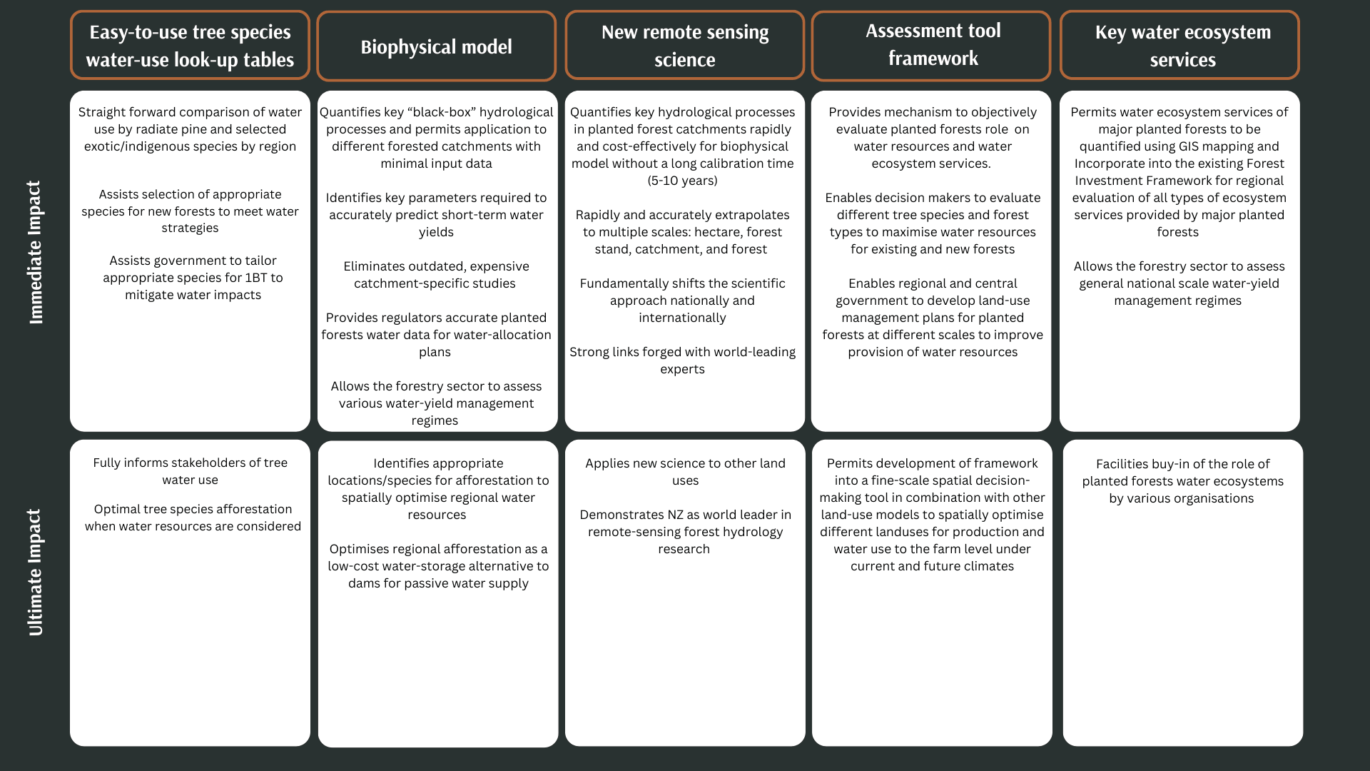
The programme aims to create a biophysical model of forest hydrology that accurately predicts water retention and release for entire catchments while also obtaining water quality and quantity data that can be updated regularly (eg. weekly). This will ensure that New Zealanders have a sustainable and reliable water supply, a reliable source of high-quality drinking water, and that our land uses preserve social and cultural values.
This programme will seek to protect primary sector productivity and improve water quality, flood mitigation and current/ future demands for rural/ urban users by qualifying water storage and release by planted forests. It will also quantify the positive and negative impacts of planted forests on water resources, including any potential impact resulting from intensification of planted forests.
It will determine whether some tree species and forest types are better at flood mitigation than others and identify planted forests that have the potential to be passive water reservoir systems.
Our team
A strong core team with relevant connections to potential end-users and experience with practical applications for research.
Related links
NZ’s new plan for clean water (NZ Herald)
Researchers seek to impact New Zealand water quality by understanding forest-water interactions (Virginia Technology)
Solving the mysteries of forest hydrology (Scion Connections)
Outputs and impact
Case studies
Immediate impact
- Demonstrates the practical application of the assessment framework by individual landowners or small catchments to determine:
a) The impact of existing/new planted forests on water use/ecosystem services; and
b) Comparison with other land uses water use/ecosystem services
- Demonstrates application to end and next users
- Provides a template for development the framework into a fine-scale spatial decision-making tool
Ultimate impact
Facilitates buy-in of the framework functionality and how it can be used in conjunction with other land-use models to maximise landowner water resources under current and future climates
Collaborators